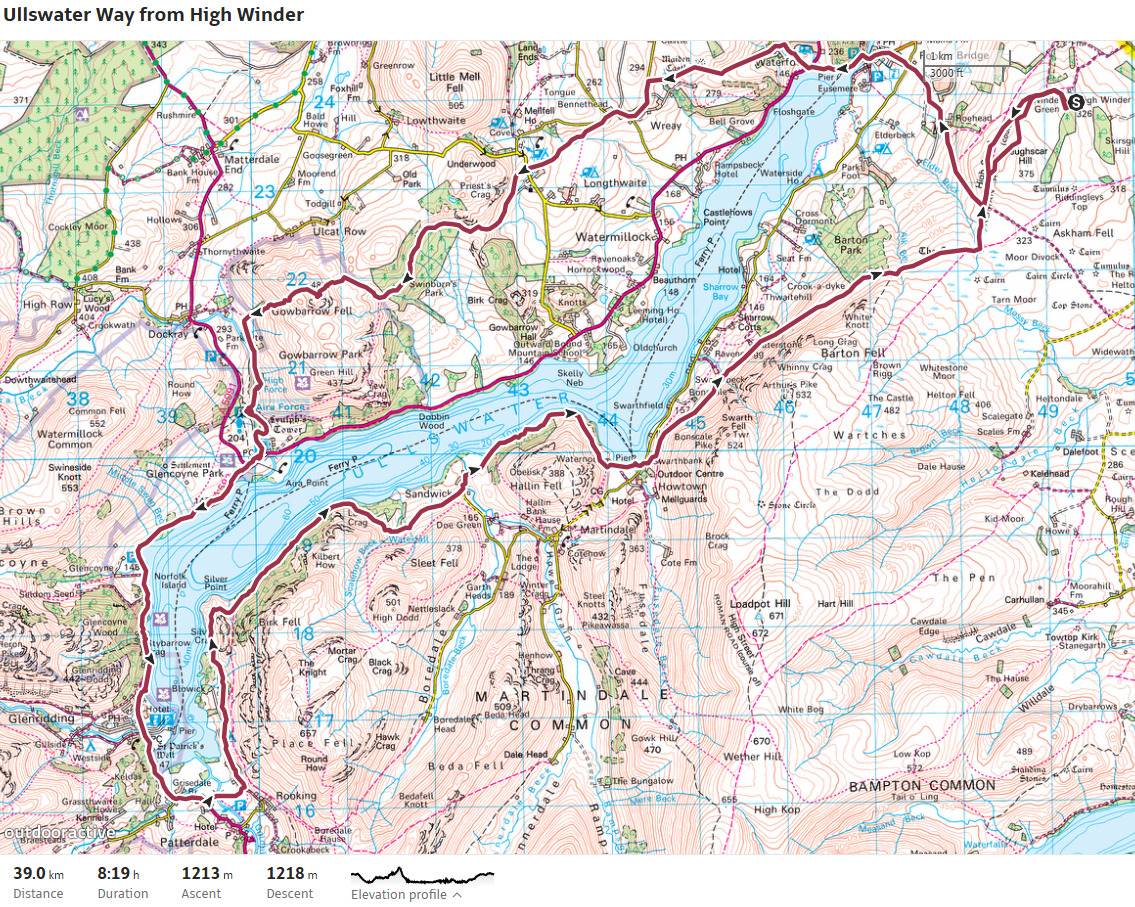
Skip To Content
Menu

Local Walks

Short Walk To Heughscar
A quick 30-minute wander directly from our propety (ideal for a quick dog walk) is to discover the beautifully quiet Heughscar. You can sit and enjoy the views of Ullswater, it’s such a relaxing spot that we find many guests wander there every day during their stay with us. Turn right after the dog exercise area onto the fell, at the end of the fence bear left and turn left onto the path, walk straight ahead for a couple of minutes.  The path then splits just after the gorse ends, the lower path follows the old Roman Road to the crossroads at the cairn of Roman Seat. Take the higher path and follow it to reach Heughscar. From here you can retrace your steps back to the cottages, or continue on and explore Askham Fell and Moor Divock.
Visit Site
Heughscar Hill Circular Walk
A nice 3km circular walk is to the summit of Heughscar Hill 375m (one of Wainwrights Outlying Fells). Turn right after the dog exercise area onto the fell, at the end of the fence bear left and turn left onto the path, walk straight ahead for a couple of minutes.  The path then splits as the gorse ends, the lower path follows the old Roman Road to the crossroads at the cairn of Roman Seat. Take the higher path and follow it to reach Heughscar. Leaving Heughscar continue straight up for about 500m to reach the summit of Heughscar Hill. Leaving Heughscar Hill head across to pass to the right of Winder Plantation heading down towards Askham. Shortly you will take the path to the left running parralel with the plantations passing the limestone formations on your left. Head between the two plantations (now mainly felled) and follow the wall to the right all the way back to High Winder.
Visit Site
Askham From High Winder
A nice walk to take is down to Askham, where there is the Village Shop and a couple of pubs. Leaving the gate by the dog field, turn left and follow the stone wall. At the end of the stone wall cut through between the two plantations heading left. Follow the path diagonally down heading towards the small plantation. Here you join the main path which is part of the Lowther Loop extension of the Ullswater Way. Follow this path all the way into Askham. Remember the return is uphill! To make it a circular walk you can return to High Winder by the road, but obvioulsy it is much nicer walking back up the fell than a single track road.
Visit Site
Pooley Bridge From High Winder
Turn right after the dog exercise area onto the fell, at the end of the fence bear left roughly following the line of the overhead wires, at the main path turn left, walk straight ahead for a couple of minutes passing the water tanks up on the right.  The path then splits just after the gorse ends, take the lower path following the old Roman Road, which takesyou to the crossroads at the cairn of Roman Seat. Shortly after passing under Heughscar, the path forks and here take the left hand fork heading down (there are other paths heading down but this one is usually the driest) Head down towards the hedge line and here keep left until you spot the obvious path heading downhill. You come to the track by the gate at Roehead, turn right heading through the gate and follow the road down. At the crossroads head straight on into Pooley Bridge. Returning from here is uphill, or you could venture further afield exploring the area by bus or by steamer.
Visit Site
Arthur's Pike
The nearest Wainwright Summit to High Winder is Arthur's Pike, it is roughly 11km there and back with an elevation gain of around 350m. The majority of which is in the last 2km climbing 200m to the summit from the path. Leaving High Winder, turn right at the gate by the dog field. At the end of the fence bear left following roughly the direction of the overhead wires. Joining the main path head left, stay on this path heading under Heughscar until you reach the crossroads at the Roman Seat, joining the Ullswater Way path head across to the Cockpit. At the Cockpit turn right along the path, passing two stream, the bigger of the two is Aik Beck and shortly after Aik Beck you take the green fellside track on the left. This is the start of the climb. Once the climb starts you are face with the choice at a fork, left hand path goes straight up the fell, pretty much all the way to the summit. (This is my downhill path) I prefer to take the right hand fork as this takes you over some stunning viewpoints, in my opinion maximising the views on the walk. With cairns marking the summits of White Knott and various crags. The finest being Whinny Crag, which is my choice for a coffee stop and a sandwich, as the actual summit of Arthur's Pike isn't the greatest. From Whinny Crag you have a short walk up to the summit passing a small cairn marking the path. From the summit of Arthur's Pike I head straight over following the grass path down over the broken wall to descend back down to the Ullswater Way path near Aik Beck to return back to High Winder on the path you came on.The fitter, more adventurous people can push on from Arthur's Pike to Bonscale Pike (about 1km further) or further along the ridge running all the way to High Street taking in several Wainwrights on the way. At High Street you can follow the Coast 2 Coast path down into Patterdale and get the bus back to Pooley Bridge. Bagging a couple more Wainwrights on the descent.
Visit Site
The Lowther Loop from High Winder
A nice scenic walk to do is the Lowther Loop extension to the Ullswater Way, taking in the antiquities of Moor Divock with Stone Age burial cairns and Stone Circles to be found, then a riverside walk along the River Lowther. With options for visiting Lowther Castle (lovely Cafe in the grounds) or a spot of food in Askham at The Punchbowl or The Queens Head. Leaving High Winder by the gate at the dog field turn right at the gate by the dog field. At the end of the fence bear left following roughly the direction of the overhead wires. Joining the main path head left, stay on this path heading under Heughscar until you reach the crossroads at the Roman Seat. Turn left here along the stone track heading towards Ketley Gate, then carry on as the path changes to a wide grassy path down Moor Divock. At the end of Moor Divock after passing the Cop Stone, turn left at the road and follow it into Helton. Turn right in Helton turning left off the road down a ginnel at a stone barn with a marker post. Cross the main road and through the gate with a finger post pointing to the Lowther Loop. Follow this path with a stone wall and barb wire fence on each side until you reach the river. Turning left at the sign post to follow the riverbank through the meadows. At Crookwathe Bridge turn right over the bridge before turning left a short while up the roads into the Lowther Estate, headin up the track towards the trees, then following the riverbank all the way to Askham Bridge (When first entering the forest just before the bridge there is a path on the right heading up to Lowther Castle)Turning right over the bridge pass by St Peters Church and up into the village of Askham passing The Punchbowl and Askham Hall, before reaching Askham Village Stores and The Queens Head at the crossroads. Head straight on at the crossroads passing all the houses and the farm before following the farm track until it reaches open fell as you start to climb up to the gate. Once past the small plantation take the path off to the right heading towards the two plantations (mostly felled now). Head through between the plantations then turn right to follow the wall all the way back to High Winder.
Visit Site
The Ullswater Way
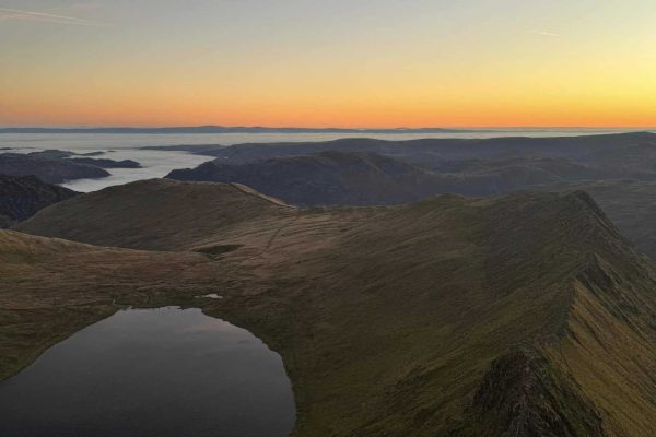
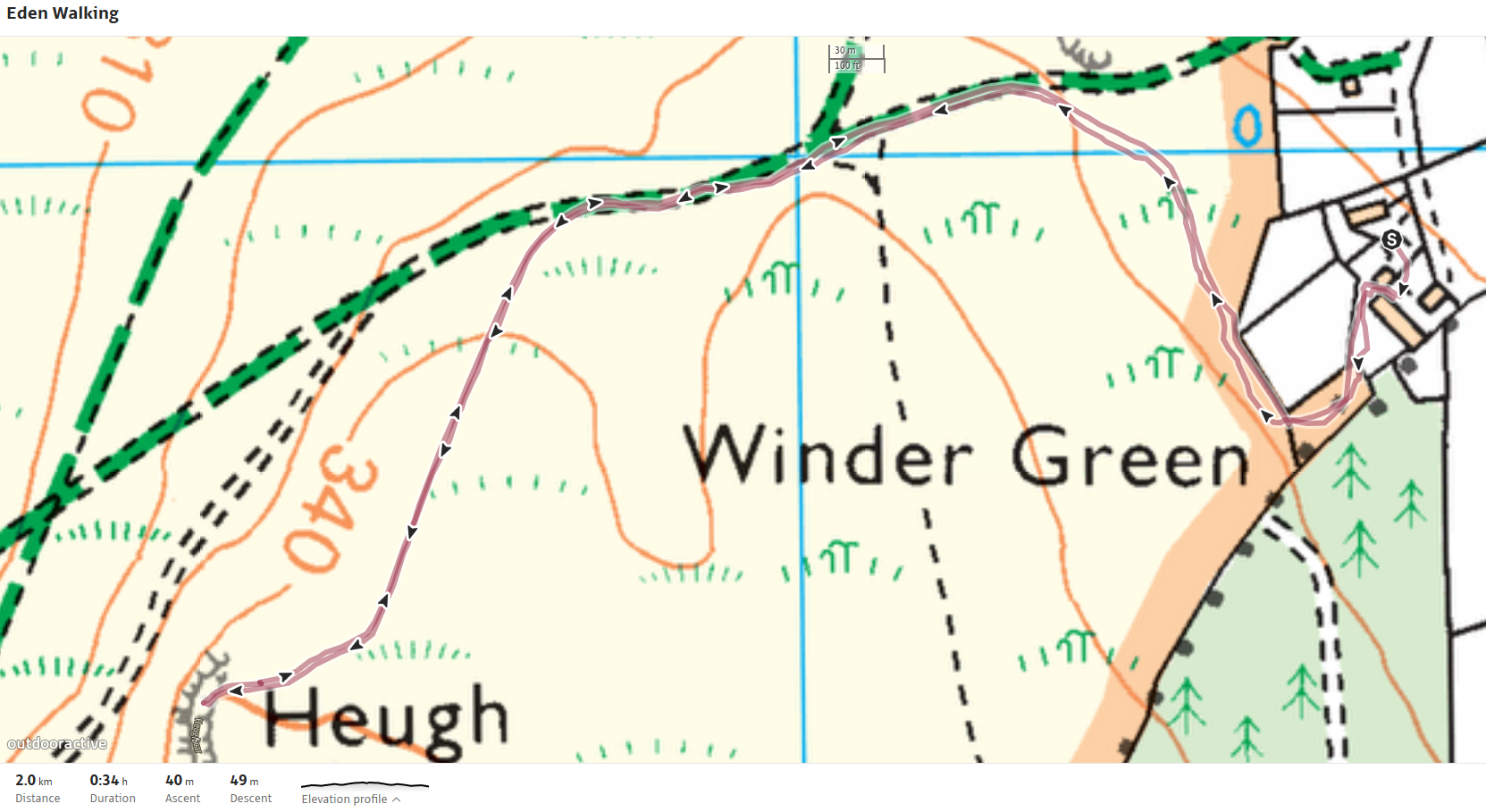
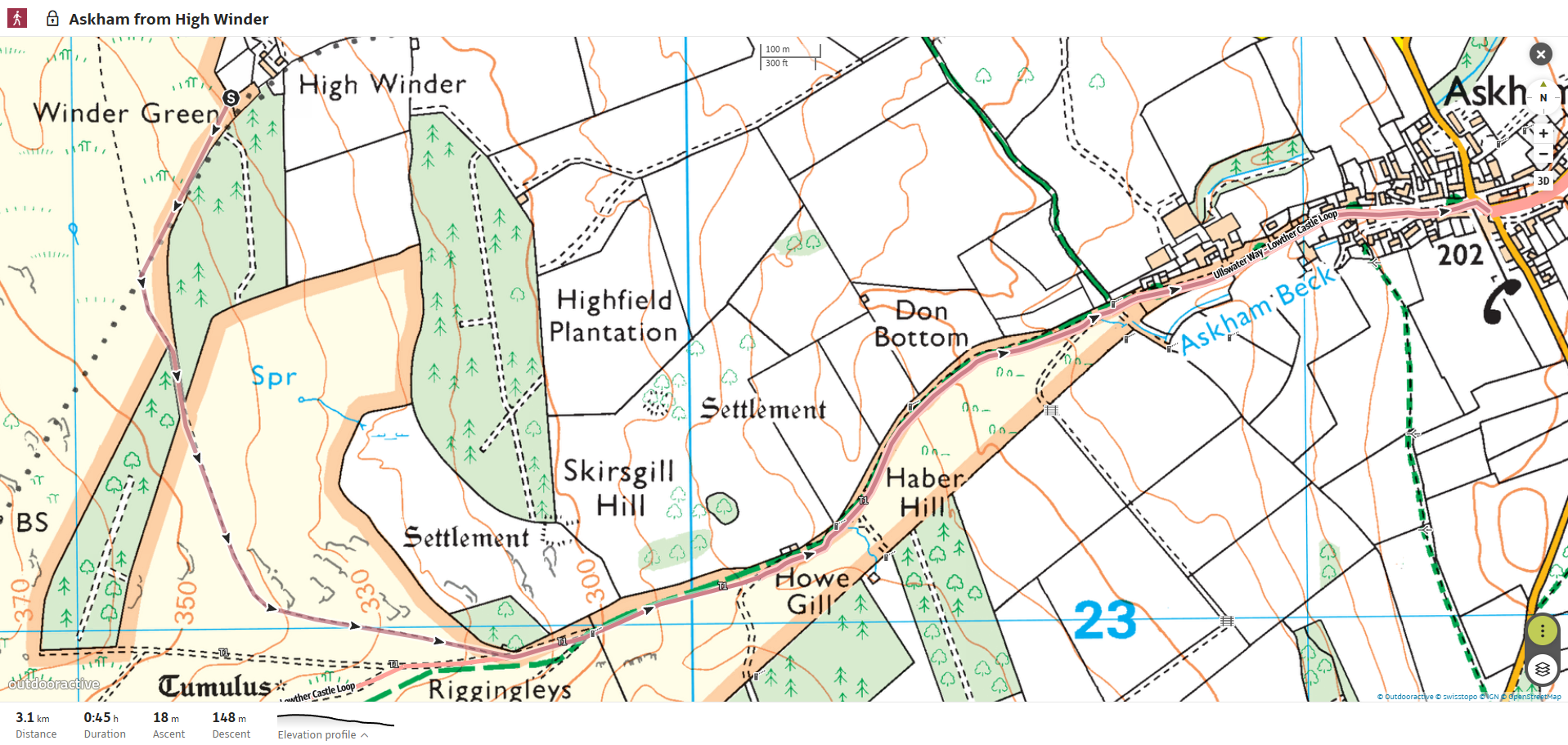
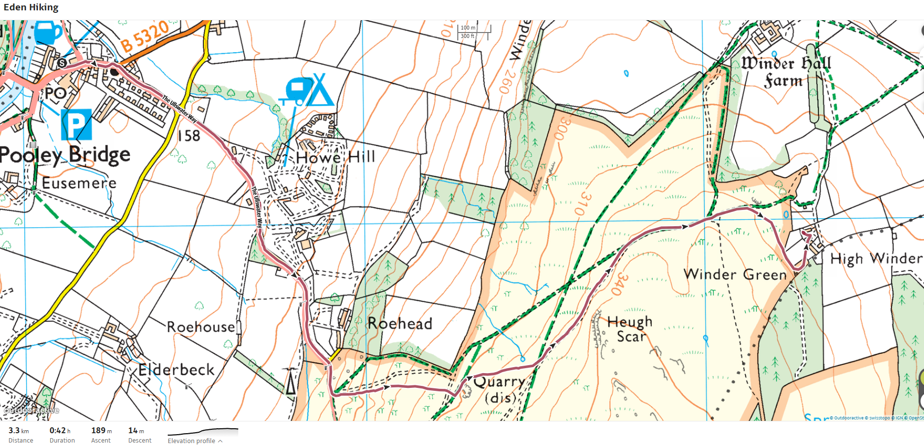
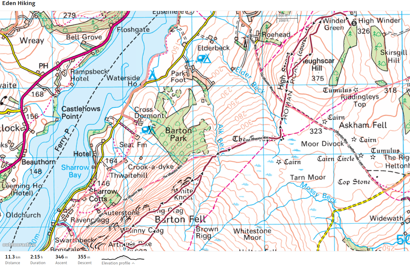
For the ultimate in LDW in the area take on the challenge of The Ullswater Way from the doorstep.  This is such a challenge that many of the charity walks in the Lake District use this such as Trek 26 for The Alzheimers Society and The Mighty Hike for Macmillan. This great walk can be done as a whole or in sections using public transport. For that purpose I will break the description down into smaller sections.1 High Winder to Aira ForceOn leaving the gardens turn right at the gate by the dog field. At the end of the fence bear left following roughly the direction of the overhead wires. Joining the main path head left, stay on this path heading under Heughscar until you reach the crossroads at The Roman Seat, joining the Ullswater Way turn right and head down into Pooley Bridge. From Pooley Bridge the Ullswater Way takes you on paths through woodland and fields to Maiden Castle. Once a defended settlement, it is now hidden by grass, but from this raised vantage point you have spectacular views down the Ullswater Valley, and also to the Pennines to the east and Blencathra to the north.The Way continues on to Bennethead and then on quiet roads to the beautifully situated Watermillock Church, before leaving the road to join a track through the quiet woods of Swinburn Park (once one of five medieval deer parks surrounding Ullswater).Option: Leaving the woods there is a choice of paths: walk round and over the summit of Gowbarrow to enter the upper reaches of Aira Force (the map shown takes this route), or continue along the path shouldering Gowbarrow, where the views open to the whole of Ullswater and the rising mountains ahead.The higher route over the summit of Gowbarrow includes the magnificent waterfalls at Aira. Allow time to explore the paths through the old woodlands and landscaped glades before reaching the spectacular stone arch bridge spanning the 65 foot waterfall.On the lower route take a rest on Memorial Seat and enjoy the panorama from this grand balcony. In the distance you will see Lyulph’s Tower – a sixteenth century castellated tower, before reaching the spectacular waterfalls of Aira Force.At Aira Force, buses are available on the main road or the Steamer jetty is across the road and in High Season you can take the Steamer to or from Pooley Bridge.2 Aira Force to GlenriddingThis section includes the magnificent waterfalls at Aira. Allow time to explore the paths through the old woodlands and landscaped glades before reaching the spectacular stone arch bridge spanning the 65 foot waterfall.The Way now passes through the ancient woodland of Glencoyne Deer Park. Most famously, Glencoyne Wood was the place where, in 1802, William and Dorothy Wordsworth saw daffodils by the lakeshore. The encounter is described in detail in a celebrated entry in Dorothy’s Grasmere Journal and inspired William Wordsworth to write his most famous poem “I wandered lonely as a cloud, That floats on high o’er vales and hills, When all at once I saw a crowd, A host of golden daffodils; Beside the lake, beneath the trees, Fluttering and dancing in the breeze.”At Glencoyne, cross the road to join a web of paths meandering beside Ullswater, where you can stop and admire the view down the lake before arriving in Glenridding. (Please take care: there is a 100m section along the side of the A592.)At Glenridding, buses are available on the main road or the Steamer jetty accesed behind the Ullswater Inn where you can take the Steamer to or from Pooley Bridge.3 Glenridding to HowtownThe Ullswater Way now weaves its way with the road, but on good paths and clear crossings. The route passes King George V playing fields – named “the prettiest field in England” by William Wordsworth, before crossing the open valley to Side Farm and heading back northwards along and above the shores of Ullswater.This section of path, described by Wainwright as “the most beautiful and rewarding walk in Lakeland” undulates through woodland and open fell giving stunning views over Ullswater and its islands. The Way passes through the little hamlet of Sandwick to reach Howtown and the steamer pier.At Howtown at certain times of the year the Ullswater Hopper bus is available or the Steamer jetty can be accesed and take the Steamer to or from Pooley Bridge.4 Howtown to High WinderJust beyond Howtown, the Way takes you up onto the moorland edge with extensive views over Ullswater.Option: At Swarthbeck, choose to continue on the open moorland to reach the Cockpit – an impressive large stone circle, before heading over to The Roman Seat where you joined the Ullswater Way earlier before heading back under Heughscar to High Winder.Or, alternatively you can take a lower path which takes you through farm land and past farmhouses to reach the Howtown road at Cross Dormont. (Having took this route on The Mighty Hike, it can be a swamp, plus you have to ascend back up to High Winder from Pooley Bridge) The path then takes you through a working sheep farm and campsite following the water’s edge round to Pooley Bridge. Then back up to Roehead before climbing up the fell to return to High Winder.
Visit Site